Fundamentals
Simultaneous Localization and Mapping (SLAM)
See it in action:
Google's official Cartographer demo, showing a live 3D point-cloud map being built from LiDAR data as the sensor moves through a space.
01Definition: a chicken-and-egg problem
Why mapping and localization must be solved together
Robotics researchers Hugh Durrant-Whyte and Tim Bailey framed the core question in their foundational 2006 tutorial: can a mobile robot placed at an unknown location in an unknown environment incrementally build a consistent map of that environment while simultaneously determining its own location within it? They called solving this a "holy grail" for making a robot truly autonomous.
The reason it can't be split into two separate steps is often described as a chicken-and-egg problem: building an accurate map requires knowing where the robot is at each moment, and figuring out where the robot is requires already having a map to compare sensor readings against. Durrant-Whyte and Bailey's own explanation goes further — every landmark a robot observes is measured relative to its own uncertain position, so the resulting map estimates are all statistically correlated with that same position error.
Map and position have to be estimated jointly — neither can be solved first.
From odometry drift to the birth of SLAM
SLAM exists because the alternative, dead reckoning, breaks down quickly. A 1997 paper on odometry error modeling put it plainly: because of wheel slippage, floor roughness, and small errors from discretized wheel-increment sampling, odometry accumulates position error "in an unbounded fashion" the longer a robot moves.
The field traces back to the 1986 IEEE Robotics and Automation Conference in San Francisco, where researchers including Peter Cheeseman, Jim Crowley, and Hugh Durrant-Whyte began applying statistical estimation methods to mapping and localization. The acronym "SLAM" itself wasn't coined until nearly a decade later, in a 1995 paper on localizing automatic guided vehicles.
How this differs from GPS
Satellite positioning (GPS) is another way a robot can find its own position.
GPS
Relies on signals from external satellites.
- Needs a clear view of the sky
- Unreliable or unavailable indoors, underground, and between tall buildings
SLAM
Builds its own reference frame from onboard sensors as the robot moves.
- No dependence on external signals — useful exactly where GPS is weak
- One option for indoor localization; approaches using fixed infrastructure such as floor markers are covered below
02Three algorithm families, and loop closure
Where GPS can't reach and no fixed infrastructure such as floor markers is in place, a robot has to solve this joint estimation problem with only its own onboard sensors. SLAM algorithms fall into three broad families: EKF-SLAM, FastSLAM, and graph-based SLAM.
EKF-SLAM
The classical, filter-based approach: robot pose and landmark positions are tracked together in one state vector via an Extended Kalman Filter.
- Rooted in the late-1980s statistical work of Peter Cheeseman, Randall Smith, and Hugh Durrant-Whyte
- Computation grows sharply as the number of landmarks increases
FastSLAM
A particle filter holds many candidate robot trajectories at once, each paired with its own small per-landmark EKF.
- Introduced by Michael Montemerlo, Sebastian Thrun, Daphne Koller, and Ben Wegbreit at AAAI 2002
- Proposed as a more scalable alternative to plain EKF-SLAM
Graph-based SLAM
Robot poses become nodes in a graph, sensor measurements become edges, and the whole graph is solved with global least-squares optimization.
- The back end used by Cartographer and ORB-SLAM below
How the processing pipeline works
Graph-based SLAM is the dominant one of the three today — here's how its processing pipeline works, from raw sensor data to an updated map.
Raw readings from LiDAR, cameras, or other sensors — a new frame arrives on every processing cycle.
Extracts a movement estimate and landmark positions from that specific sensor's data — the exact technique differs by sensor type.
Registers the estimate into the pose graph and re-optimizes it — the same process regardless of which sensor produced the input.
The current best estimate of the robot's trajectory and the map, carried forward into the next cycle.
MathWorks' official "Autonomous Navigation" series explains pose graph optimization — the backend step in the pipeline above — in more depth.
At the core of graph-based SLAM is loop closure: detecting from sensor data that the robot has returned to a place it visited before, then using that match to correct accumulated drift across the entire graph at once.
That correction is what keeps a robot's map from drifting further out of shape the longer it explores.
Loop closure doesn't always work correctly. When different places look alike — perceptual aliasing — the system can mistake one location for another and insert a wrong constraint, making the map worse instead of better. A 2026 benchmark paper (a preprint, not yet peer-reviewed) tested ORB-SLAM3 across kilometer-scale synthetic outdoor sequences and found that in a repetitive desert environment, enabling loop closure raised one run's position error from 4.12 meters to 37.85 meters because the system accepted a spurious match.
From ORB-SLAM to foundation-model SLAM
The graph-based family has kept evolving well past its 1990s origins — absorbing photorealistic 3D-rendering techniques from computer-vision research, and, most recently, building on general-purpose 3D-reconstruction foundation models instead of a SLAM-specific network trained from scratch.
- 2015
ORB-SLAM
Real-time monocular visual SLAM
- 2021
ORB-SLAM3
Adds visual-inertial fusion, multi-map
- 2024
Gaussian Splatting SLAM
3D Gaussians as the map, live photorealistic rendering
- 2025
MASt3R-SLAM
A 3D-reconstruction foundation model as SLAM's prior, not a purpose-built SLAM network
The MASt3R-SLAM authors' own demo video (Murai et al., CVPR 2025), showing dense 3D reconstruction built in real time.
03LiDAR SLAM vs. Visual SLAM
Algorithm families are one axis; SLAM also splits by which sensor does the sensing.
LiDAR SLAM
Uses laser ranging to measure surrounding geometry directly, so it can work without ambient light.
- Google's Cartographer library, open-sourced on October 5, 2016, supports real-time 2D and 3D mapping plus ROS integration
- The trade-off is the cost of dedicated sensing hardware and, for rotating units, additional mechanical complexity
Visual SLAM (VSLAM)
Uses ordinary cameras, keeping dedicated sensor cost low.
- ORB-SLAM — which opens section 02's timeline — from Raúl Mur-Artal, J.M.M. Montiel, and Juan D. Tardós at the University of Zaragoza (2015, IEEE Transactions on Robotics Best Paper Award), is a widely used open-source example
- Extracting and tracking visual features takes more compute, and performance can degrade in darkness or texture-poor scenes
LiDAR sensor cost and the competition to supply robotics customers are covered in more depth in our sensors & perception market article.
Combining both: hybrid systems
Some systems combine both sensing approaches. An RGB-D camera pairs an ordinary color camera with a depth sensor in the same unit, giving Visual SLAM's lower hardware cost some of LiDAR's ability to measure geometry directly, without a separate laser scanner.
KinectFusion, an early system built on Microsoft's Kinect depth camera, showed in 2011 that a full real-time 3D surface reconstruction was possible from exactly this kind of low-cost combined sensor.
04From robot vacuums to warehouse robots
Consumer robots: laser and camera mapping
The scale and cost of a SLAM implementation vary enormously with what it's built into — and the laser-versus-camera split from section 03 shows up directly in consumer products.
Among home robots, Neato Robotics' XV-11 (which began shipping in June 2010) is an early example of a consumer robot mapping a room with a rotating laser sensor, and iRobot's Roomba 980 (released September 2015) was the first Roomba built on iRobot's own camera-based SLAM, which the company calls vSLAM.
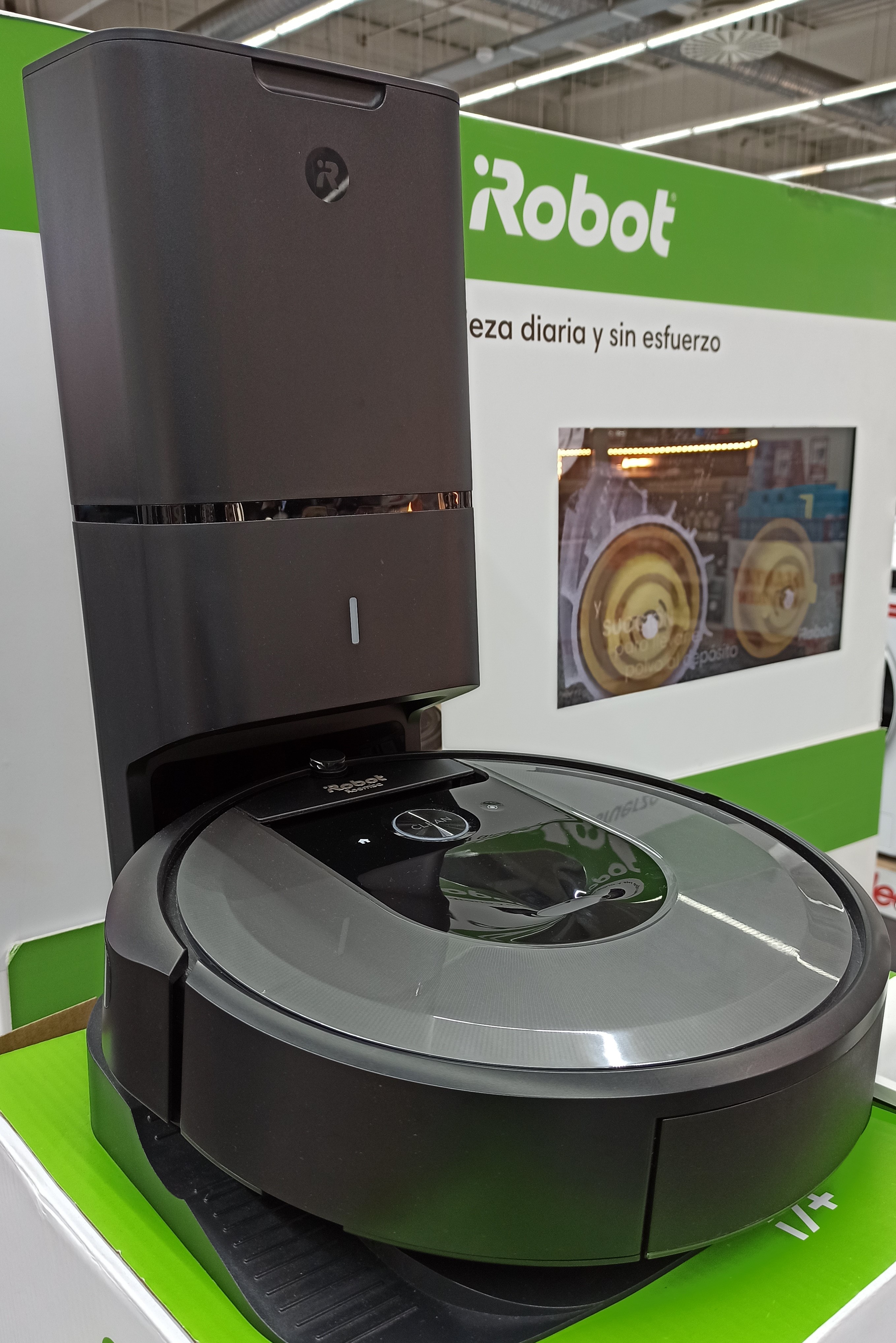
iRobot's Roomba line has used camera-based SLAM (vSLAM) since the 980 in 2015; the i7+ pictured here is a later model in the same lineage.
Photo: Auledas, CC BY-SA 4.0, via Wikimedia CommonsConfigurable and open-source SLAM stacks
Some industrial and research robots let a user choose the SLAM approach for the job. AgileX Robotics' official LIMO manual documents two LiDAR SLAM workflows: Gmapping, described for smaller spaces, and Google's graph-optimization-based Cartographer, which performs real-time loop closure.
Nav2, the standard navigation stack of the ROS 2 robot framework, includes SLAM Toolbox (created by Steve Macenski) as its default SLAM implementation. Nav2's official SLAM tutorial demonstrates the stack on TurtleBot3, a common research platform.
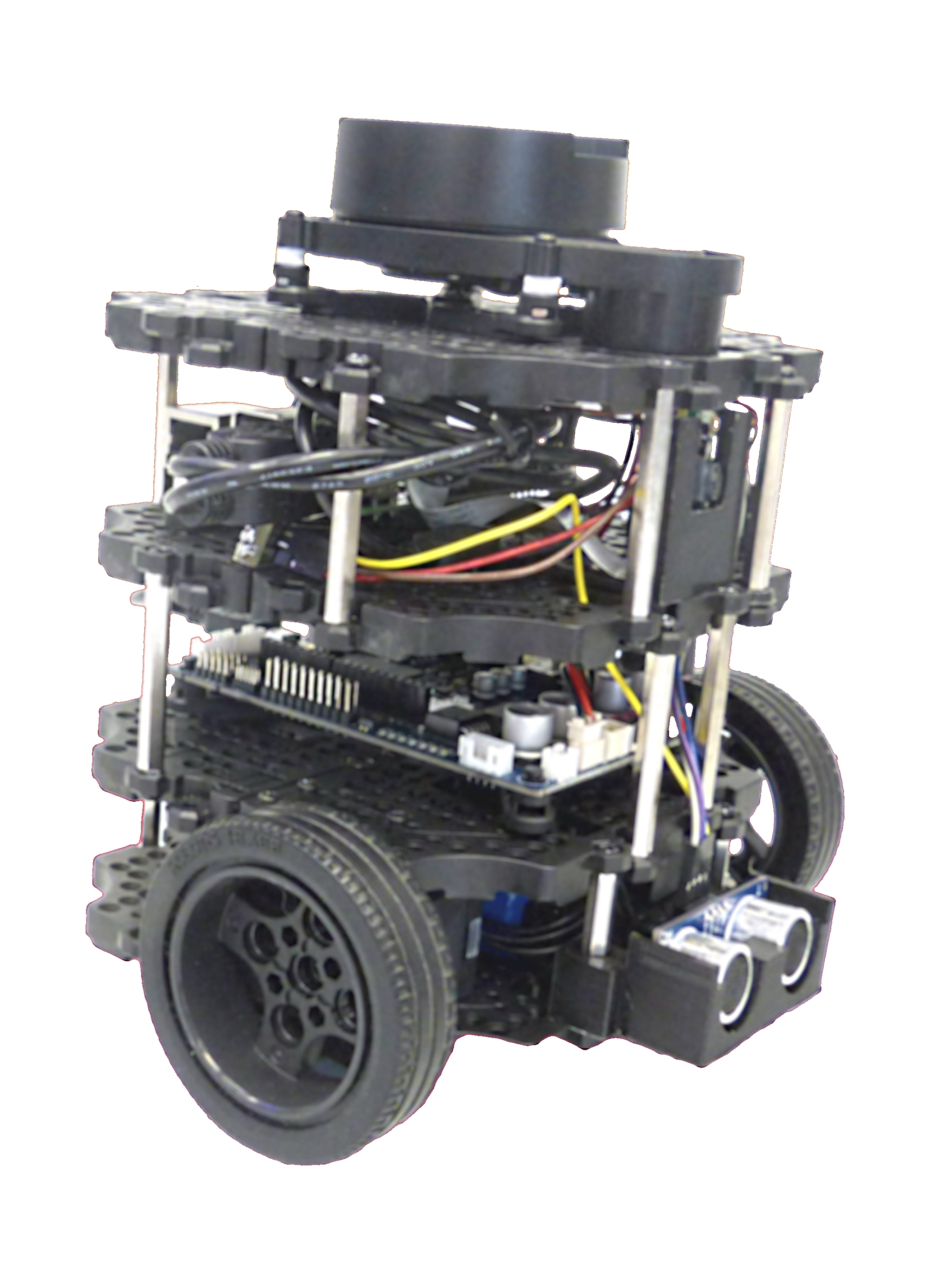
TurtleBot3 — the platform Nav2's official SLAM tutorial uses to demonstrate SLAM Toolbox.
Photo: Kuscu0, CC BY-SA 4.0, via Wikimedia CommonsFixed infrastructure as an alternative to SLAM
Not every autonomous mobile robot (AMR) actually runs SLAM.
Amazon says Hercules, one of its warehouse drive units, reads a grid of encoded floor markers for localization, while Pegasus operates in the same kind of structured field. These systems show that an AMR (autonomous mobile robot) can navigate autonomously using fixed infrastructure; SLAM is one alternative when a robot must localize in spaces that are not prepared with those markers.
Mobile-robot market growth
ABI Research identifies SLAM as one of the technologies enabling mobile robots to expand beyond their traditional stronghold in warehousing and logistics into more varied, less structured environments. The firm's December 2024 forecast shows some of the fastest growth in exactly the newer segments where that flexibility matters most: agricultural robot shipments are projected to grow from 7,000 units in 2023 to 129,000 by 2030 (a 45% CAGR), delivery robots from 14,000 to 147,000 (37%), and restaurant robots from 6,000 to 78,000 (43%). As ABI Research robotics analyst George Chowdhury put it, mobile robots are "expanding automation to previously under-automated sectors" — deployments that depend on a robot being able to localize itself in a space nobody mapped out for it in advance.
Mobile robot shipments, ABI Research forecast (Dec 2024)
05Open technical challenges
As those deployments spread, SLAM's remaining limits matter more. The perceptual-aliasing failures covered in section 02 aren't the only open problem — two areas in particular still limit what SLAM can reliably do today.
Real-world robustness
Research benchmarks are far tidier than the messy job sites and warehouses SLAM actually has to work in.
- The Hilti x Trimble x Oxford SLAM Challenge 2026 tests systems on 30 sequences from active construction sites
- Those sites are dynamic, GPS-denied, and rearranged day to day
- The gap between clean benchmarks and real conditions is still wide
Understanding the scene, not just its shape
Semantic SLAM tries to have a robot recognize what each mapped object actually is, not just where it is. A 2025 review found two open problems:
- Previously unseen object categories — recognition can drift as the scene changes ("semantic drift")
- The heavy computational cost of running large recognition models in real time on hardware a mobile robot can actually carry
One active response to the semantic and generalization limits above is already showing up in section 02's algorithm timeline: foundation-model SLAM, which reuses a general-purpose 3D-reconstruction model instead of training a SLAM-specific network from scratch.
06Easier ways to put SLAM to work
Those open problems are for researchers to chip away at — most teams just need SLAM that works today. Building a SLAM stack from scratch, or configuring an open-source one like the ROS options in section 04, isn't the only path anymore. Three kinds of ready-made options now handle the SLAM itself so developers don't have to.
Licensable SLAM modules
SLAMTEC's SLAMKit packages SLAM as software a robot maker licenses and embeds, rather than a research codebase a team has to integrate from scratch:
- C++, Java, ROS, and RESTful API interfaces
- The company says it cuts compute requirements by roughly half compared with other software it has benchmarked against
- Runs on ordinary Intel or ARM hardware
SLAM built into your phone
Outside robotics, Apple's ARKit and Google's ARCore embed the same core idea directly into iOS and Android: visual-inertial odometry, fusing camera images with motion-sensor data — the same drift-correcting principle covered earlier for wheeled robots.
- Any app developer building on these frameworks gets real-time 6-degree-of-freedom tracking
- No SLAM code to write themselves
Toolboxes for research and prototyping
MathWorks packages SLAM into MATLAB and Simulink toolboxes rather than a single all-in-one product:
- Navigation Toolbox includes a SLAM Map Builder app that turns recorded LiDAR data into an occupancy-grid map through a GUI
- Computer Vision Toolbox covers visual SLAM approaches like ORB-SLAM
- Prebuilt functions handle pieces like pose graphs and bundle adjustment — not a no-code black box, but it replaces writing that math from scratch
SourceMathWorks, What Is SLAM?
07Sources
01. Definition: a chicken-and-egg problem
02. Three algorithm families, and loop closure
03. LiDAR SLAM vs. Visual SLAM
04. From robot vacuums to warehouse robots
06. Easier ways to put SLAM to work
Fundamentals
All Fundamentals articles →Industrial Robot Fundamentals
Physical AI Concepts
Robot Foundation Models
Hardware Fundamentals
Movement & Perception Fundamentals
- ›Simultaneous Localization and Mapping (SLAM)(this article)